Avoid all rain
Stay on dry roads for as long as possible.
Best for cautious rides- 1 hr 37 min
- 72 mi
- 4.2 mi wet
DryRide compares route options with rain and wind forecasts, so motorcycle riders can choose the route with less wet-road exposure.
iPhone-only navigation planning for motorcycle riders.
Riders don't just need the quickest route. They need to know which option avoids wet roads, heavy showers, and weather surprises.
Using Apple MapKit route alternatives and WeatherKit forecast checks, DryRide highlights the driest practical route while still showing time and distance trade-offs.
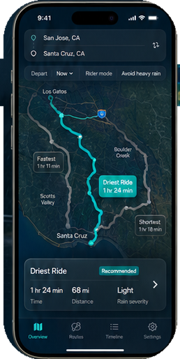
| Route options | Time | Distance | Rain severity | Wet-road distance | First rain window |
|---|---|---|---|---|---|
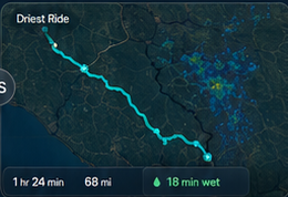
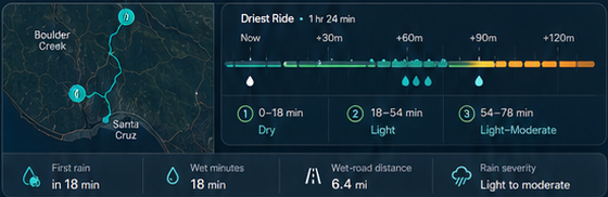
| Driest Ride Recommended | 1 hr 24 min | 68 mi | Light | 6.4 mi | in 18 min |
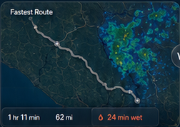
| Fastest | 1 hr 11 min | 62 mi | Moderate | 15.2 mi | in 11 min |
| Shortest | 1 hr 18 min | 57 mi | Moderate | 13.7 mi | in 14 min |
Times include current traffic. Forecasts update as you adjust your depart time.
Check wet minutes, wet-road distance, and when rain is expected to begin, so you can judge whether a route is worth it before you leave.
Avoid all rain, avoid heavy rain, or save time when showers are minor. DryRide helps you pick the route that matches how you ride.
Stay on dry roads for as long as possible.
Best for cautious ridesAllow light rain to save time without big downpours.
BalancedAccept more light rain to arrive sooner.
Fastest optionA focused utility app that keeps route planning simple.
Open and ride.
Your data stays on your device.
No ads. Ever.
Reliable routing from Apple.
Accurate forecasts from Apple.

DryRide is a planning aid. Review your route before setting off, and pull over safely before interacting with the app.
Forecasts can change. Always use your own judgment and ride to the conditions.
Short answers for riders deciding whether DryRide is useful before a ride.
The iPhone app has been built and is being prepared for App Store release. The download link will be added here as soon as it is live.
Yes. The first version is built for iPhone and uses Apple MapKit and WeatherKit for route and forecast data.
No. DryRide is a planning aid. Forecasts can change, so riders still need to review the route and ride to the conditions.
No. DryRide is designed as a focused planning utility with no account, no ads, and no tracking.
The iPhone app is built. The download link will be added here as soon as it is live.
Send the App Store URL when it is live and this button can go straight to the listing.